Helvellyn
(3117ft)
Route 7.58 miles (Memory Map Route File)
26th September 2007
This mountain has been calling me for the last couple of months, and since the whole of the summer has been a wash out I decided to book the day off and attempt to tackle this mountain, my first attempt at the Lakeland Fells.
Legend an poetry, a lovely name and a lofty altitude combine to encompass Helvellyn in an aura of romance; and thousands of pilgrims aided by its easy accessibility are attracted to its summit every year. There is no doubt that Helvellyn is climbed more often than any other mountain in Lakeland. – A. Wainwright
 Alfred Wainwright points out that whilst the western routes are easy they lack the excitement that reveals Helvellyn’s true character. So despite my lack of experience I decided to ascend from Glenridding on the shores of Ullswater.
Arriving at Glenridding at 8am, I started my carefully planned my route and almost immediately took a wrong turning as I wasn’t sure which signpost for Helvellyn I needed to take. As I found out later this was probably an easier route than the one I had planned
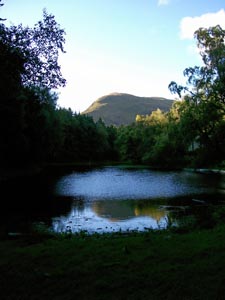
Following the path up the southern bank of Glenridding Beck I took the left hand path up the hill rather than the right hand one that follows the Beck. This brought me out at Lanty’s Tarn a small wooded lake. It may not have been planned but the view of Birks across the lake was stunning and one I could easily have missed.
Thanks to the popularity of the Lake District, the paths in the area are well trodden so on a fine day, its almost impossible to get hopelessly lost (as opposed to simply not knowing where you are) and having taken a right turn at the end of the Tarn I was soon following a likely looking path along the side of Grisedale heading for a point known as Hole-in-the-Wall.
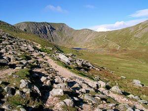
I’m not the fittest of people, and this part was a long slog puffing and panting up the stony footpath all the way up to the ridge. So far it had been pleasant, a nice warm, sunny day but as I reached the ridge my ears froze instantly as I was hit by the winds howling over Birkhouse Moor.
By now I could see Helvellyn’s peak and Swirral Edge above Red Tarn and began wondering if I was doing the right thing as my planned descent along that edge looked rather daunting, and that was supposed to be the easier of the two!!
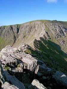
Working my way up the slope I started to get my first views of Striding Edge. My Grandpa had told me that the Edge was a pleasant stroll, unfortunately, I know him as a portly gentleman with angina, not the fit young rock climber that he used to be. I could see stretches of path across the ridge, but what was worrying me at the moment was that it seemed to end at a sheer cliff!
Early writers regarded Striding Edge as a place of terror; contemporary writers, following a modern fashion are inclined to dismiss it of little account. In fact, Striding Edge is the finest ridge there is in Lakeland – A. Wainwright
 I’m certainly with the “early writers” on this, my picture of Striding Edge was taken at the point I bottled it, I couldn’t see any way down from the where I was and had sat down to avoid being blown off by the wind, I was starting to feel extremely dubious about going back. They say that the camera doesn’t lie but the picture fails to capture how impossible the whole thing looks.
Just as I was considering booking a flight on the big yellow helicopter, salvation came along springing from rock to rock like a mountain goat.
As he came to a stop, I forced myself to stand up and chat about the route ahead. He complimented me on my choice of fells for my first attempt (which I’m sure translates to – “We’ve got a right nutter here”). I’d considered that this might be an opportunity to watch someone else do the Edge before attempting it myself or ordering the helicopter, but he (I forget his name) offered to lead me across.
Not sure if this was a good idea or not, but overtaken by a reluctance to look a coward in front of anyone else, I took him up on his offer.
The trek across wasn’t any where near as bad as it looked, although without an experienced guide who knows the route, I’d have been pushed to make it across, its a scramble rather than a walk but the only really challenging bit was just before the end, a part called the Chimney) a descent of around 20ft that looks as though it would need ropes and harness.
Finally at the other end we were faced by the final ascent to the summit, which if anything looked more impossible now than it did from a distance. My guide pointed out that there was a path, but being covered in shale, it was easier to scramble up the rock face than take 1 step forward, 2 steps back. There was no chance of me turning back at this point and feeling a little more confident after the Edge I decided to follow my guide.
I’m sure that my companion took it easy, but to me it felt like we were sprinting up the rock face and I was gasping for air all the way up. Reaching the top I was glad that I came across Striding Edge this way as I was confronted by a memorial.
Beneath this spot were found in 1805 the remains of Charles Gough.
Killed by a fall from these rocks. His dog was still guarding the skeleton.
We took a few minutes to rest at the shelter, and then a nice easy walk past the summit and to the cairn that marks the start of Swirral Edge, where we parted company.
After Striding Edge, it’s smaller sibling which had looked impossible half an hour earlier was now a fun little jaunt down to the path leading to Red Tarn.
Given the choice of the direct route or a quick jaunt up Catstycam I decided that discression was the better part of valour and left that peak for another day.
With my map having made a bid for freedom on top of Helvellyn (its probably half way across the Atlantic by now) it was reassuring to follow the well maintained (but long) path back down to Glenridding.


